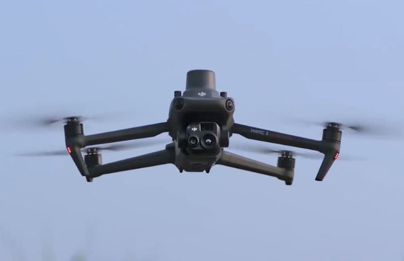
DJI Mavic 3TA
Code: 6215


Product detailed description
DJI Mavic 3T Advanced (M3TA) is a commercial drone featuring an upgraded thermal camera for more precise temperature measurement and clearer images. It builds on the proven Mavic 3 Enterprise airframe, which includes a 48MP wide-angle camera, a 12MP telephoto camera, up to 45 minutes of flight time, and omnidirectional obstacle sensing. The M3TA is designed for professional applications like emergency services, industrial inspections, and public safety, thanks to its improved thermal imaging capabilities and support for accessories like the RTK module for centimeter-level positioning.
DJI Mavic 3TA drone key thermal improvements
The headline change in the DJI 3TA is its refined thermal camera. The new unit features a 41.2° DFOV (Diagonal Field of View) and a 60 mm equivalent focal length, while preserving the same 640 × 512 resolution as before. In contrast, the original Mavic 3T used a 61° DFOV and a 40 mm equivalent focal length. The thermal field of view is narrowing improved object discernment in mid-to-long ranges.
Another noteworthy change is a smaller pixel pitch: whereas the 3T’s thermal sensor used a 12 µm pitch, the 3TA - 8 µm, which could enhance sensitivity and sharpness in the thermal domain. Temperature measurement behavior and speed appear unaffected, with both variants using an uncooled VOx microbolometer array with a 30 Hz frame rate, supporting spot/area temperature metering, and maintaining an approximate NETD (Noise Equivalent Temperature Difference) of ≤ 50 mK at f/1.0. The temperature measurement range remains the same: –20 to 150 °C in “high gain” mode or up to 500 °C in low gain mode.
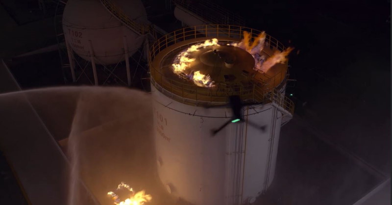
By tightening the DFOV and increasing focal length, DJI Mavic 3TA may aim to better resolve smaller heat sources at a distance — for instance, in power-line inspection, energy facility surveys, or search and rescue scenarios. However, the tradeoff is that a narrower field covers less area per shot, so flight planning may need adjustment.
Beyond the thermal side, the 3TA largely preserves the strengths of the 3T
- Imaging suite: Like the 3T, the 3TA retains the 48 MP wide-angle camera (1/2-inch CMOS, ~24 mm equivalent) with the 84° field of view, and a 12 MP telephoto (162 mm equivalent) for high-magnification detail and hybrid zoom (up to 56×).
- Flight performance: Maximum flight time remains ~45 minutes (no wind) using the same flight battery and propeller design.
- Weight and dimensions: The airframe carries a base weight around 920 g and a maximum takeoff capacity of about 1,050 g.
- Sensing and navigation: It continues to use an omnidirectional vision system (binocular stereo + infrared downward), supplemented by GPS, GLONASS, and BeiDou, with optional RTK support for centimeter-level positioning.
- Transmission and control: DJI’s O3 Enterprise transmission remains standard, offering robust link stability over complex terrain.
- Accessories and system integration: The 3TA is expected to slot into the DJI Enterprise ecosystem — meaning compatibility with modules like RTK, loudspeaker, DJI RC Pro Enterprise controller, and enterprise software tools for mission planning and thermal analysis.
To accompany the launch, DJI has rolled out a firmware update to ensure seamless integration of the Mavic 3TA with existing controllers and software.
- Aircraft firmware: v14.02.00.22 (Mavic 3T Advanced) / v14.01.00.02 (Mavic 3T/3E)
- Remote controller firmware: v02.01.07.12
- DJI Pilot 2 app: v14.2.0.15
- DJI Assistant 2: v2.1.20
The most notable addition is on the controller side: support for the Mavic 3T Advanced has been officially added, ensuring operators can update and fly without compatibility hiccups.
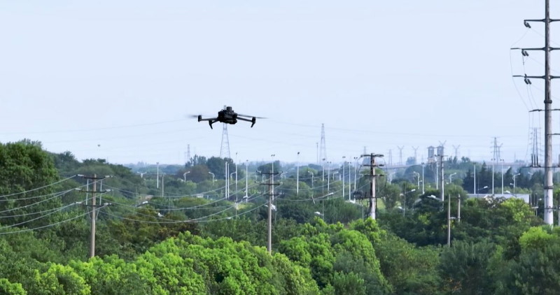
DJI Mavic 3T Advanced suitable for enterprise users who want sharper thermal granularity without jumping to a significantly different drone series. Such as inspections over long distances, industrial monitoring, or missions where thermal detail (rather than wide coverage) is paramount.
Specs
Aircraft
Weight (with propellers, without accessories) 920 g
Max Takeoff Weight 1050 g
* With DJI Mavic 3 Enterprise Series Battery (EU C1 Version) and DJI Mavic 3 Enterprise Series Low-Noise Propellers, the max takeoff weight of DJI Mavic 3E/3T/3TA is 899 g.
** Note: A Mavic 3 Enterprise Series drone with a C2 label cannot be considered C1-compliant if used with an EU-C1 version battery.
Dimensions
Folded (without propellers): 221×96.3×90.3 mm (L×W×H)
Unfolded (without propellers): 347.5×283×107.7 mm (L×W×H)
Diagonal Distance 380.1 mm
Max Ascent Speed
6 m/s (Normal Mode)
8 m/s (Sport Mode)
Max Descent Speed
6 m/s (Normal Mode)
6 m/s (Sport Mode)
Max Flight Speed (at sea level, no wind)
15 m/s (Normal Mode)
Forward: 21 m/s, Side: 20 m/s, Backward: 19 m/s (Sport Mode)
Max Wind Speed Resistance 12 m/s
Max Take-off Altitude Above Sea Level 6000 m (without payload)
Max Flight Time (no wind)
45 minutes (with DJI Mavic 3 Series Intelligent Flight Battery and DJI Mavic 3 Enterprise Series Propellers)
36 minutes (with DJI Mavic 3 Enterprise Series Battery (EU C1 Version) and DJI Mavic 3 Enterprise Series Low-Noise Propellers)
Note: A Mavic 3 Enterprise Series drone with a C2 label cannot be considered C1-compliant if used with an EU-C1 version battery.
Max Hovering Time (no wind)
38 minutes (with DJI Mavic 3 Series Intelligent Flight Battery and DJI Mavic 3 Enterprise Series Propellers)
30 minutes (with DJI Mavic 3 Enterprise Series Battery (EU C1 Version) and DJI Mavic 3 Enterprise Series Low-Noise Propellers)
Note: A Mavic 3 Enterprise Series drone with a C2 label cannot be considered C1-compliant if used with an EU-C1 version battery.
Max Flight Distance
32 km (with DJI Mavic 3 Series Intelligent Flight Battery and DJI Mavic 3 Enterprise Series Propellers)
24 km (with DJI Mavic 3 Enterprise Series Battery (EU C1 Version) and DJI Mavic 3 Enterprise Series Low-Noise Propellers)
Note: A Mavic 3 Enterprise Series drone with a C2 label cannot be considered C1-compliant if used with an EU-C1 version battery.
Max Pitch Angle
30° (Normal Mode)
35° (Sport Mode)
Max Angular Velocity 200°/s
GNSS GPS+Galileo+BeiDou+GLONASS (GLONASS is supported only when the RTK module is enabled)
Hovering Accuracy
Vertical: ±0.1 m (with Vision System); ±0.5 m (with GNSS); ±0.1 m (with RTK)
Horizontal: ±0.3 m (with Vision System); ±0.5 m (with High-Precision Positioning System); ±0.1 m (with RTK)
Operating Temperature Range -10° to 40° C (14° to 104° F)
Internal Storage N/A
Motor Model 2008
Propeller Model 9453F Propellers for Enterprise
Beacon Built into the aircraft
Class C2 (EU)
Wide Camera
Sensor 1/2-inch CMOS, Effective pixels: 48 MP
Lens
FOV: 84°
Equivalent Focal Length: 24mm
Aperture: f/2.8
Focus: 1 m to ∞
ISO Range 100-25600
Shutter Speed
Electronic Shutter: 8-1/8000 s
Max Image Size 8000×6000
Still Photography Modes
Single: 12 MP/48 MP
Timed: 12 MP/48 MP
JPEG: 2/3/5/7/10/15/20/30/60 s*
Panorama: 12 MP (raw image); 100 MP (stitched image)
* Shooting 48MP photo does not support 2s interval
Smart Low-light Shooting: 12 MP
Video Resolution
H.264
4K: 3840×2160@30fps
FHD: 1920×1080@30fps
Bitrate
4K: 85 Mbps
FHD: 30 Mbps
Supported File Formats exFAT
Photo Format JPEG
Video Format MP4 (MPEG-4 AVC/H.264)
Tele Camera
Sensor
1/2-inch CMOS, Effective pixels: 12 MP
Lens
FOV: 15°
Equivalent Focal Length: 162mm
Aperture: f/4.4
Focus: 3 m to ∞
ISO Range
DJI Mavic 3E: 100-6400
DJI Mavic 3T/3TA: 100-25600
Shutter Speed
Electronic Shutter: 8-1/8000 s
Max Image Size 4000×3000
Photo Format JPEG
Video Format MP4 (MPEG-4 AVC/H.264)
Still Photography Modes
Single: 12 MP
Timed: 12 MP
JPEG: 2/3/5/7/10/15/20/30/60 s
Smart Low-light Shooting: 12 MP
Video Resolution
H.264
4K: 3840×2160@30fps
FHD: 1920×1080@30fps
Bitrate
4K: 85 Mbps
FHD: 30 Mbps
Digital Zoom 8x (56x hybrid zoom)
Thermal Camera
Thermal Imager
Uncooled VOx Microbolometer
Pixel Pitch 8 μm
Frame Rate 30 Hz
Lens
DFOV: 41.2°
Equivalent Focal Length: 60mm
Aperture: f/1.0
Focus: 5 m to ∞
Noise Equivalent Temperature Difference (NETD) ≤50 mK@F1.0
Temperature Measurement Method
Spot Meter, Area Measurement
Temperature Measurement Range
-20° to 150° C (-4° to 302° F, High Gain Mode)
0° to 500° C (32° to 932° F, Low Gain Mode)
Palette White Hot/Black Hot/Tint/Iron Red/Hot Iron/Arctic/Medical/Fulgurite/Rainbow 1/Rainbow 2
Photo Format JPEG (8-bit), R-JPEG (16-bit)
Video Resolution 640×512@30fps
Bitrate 6 Mbps
Video Format MP4 (MPEG-4 AVC/H.264)
Still Photography Modes
Single: 640×512
Timed: 640×512
JPEG: 2/3/5/7/10/15/20/30/60 s
Digital Zoom
28x
Infrared Wavelength
8-14 μm
Infrared Temperature Measurement Accuracy
High Gain: ±2°C or ±2% (using the larger value)
Low Gain: ±5°C or ±3% (using the larger value)
Gimbal
Stabilization 3-axis (tilt, roll, pan)
Mechanical Range
Tilt: -135° to 45°
Roll: -45° to 45°
Pan: -27° to 27°
Controllable Range
Tilt: -90° to 35°
Pan: Not controllable
Max Control Speed (tilt) 100°/s
Angular Vibration Range ±0.007°
Sensing
Type Omnidirectional binocular vision system, supplemented with an infrared sensor at the bottom of the aircraft.
Forward
Measurement Range: 0.5-20 m
Detection Range: 0.5-200 m
Effective Sensing Speed: Flight Speed ≤15 m/s
FOV: Horizontal 90°, Vertical 103°
Backward
Measurement Range: 0.5-16 m
Effective Sensing Speed: Flight Speed ≤12 m/s
FOV: Horizontal 90°, Vertical 103°
Lateral
Measurement Range: 0.5-25 m
Effective Sensing Speed: Flight Speed ≤15 m/s
FOV: Horizontal 90°, Vertical 85°
Upward
Measurement Range: 0.2-10 m
Effective Sensing Speed: Flight Speed ≤6 m/s
FOV: Front and Back 100°, Left and Right 90°
Downward
Measurement Range: 0.3-18 m
Effective Sensing Speed: Flight Speed ≤6 m/s
FOV: Front and Back 130°, Left and Right 160°
Operating Environment
Forward, Backward, Lateral, and Upward: Surface with a clear pattern and adequate lighting (lux >15)
Downward: Diffuse reflective surface with diffuse reflectivity>20% (e.g. walls, trees, people) and adequate lighting (lux >15)
Video Transmission
Video Transmission System DJI O3 Enterprise Transmission
Live View Quality Remote Controller: 1080p/30fps
Operating Frequency
2.400-2.4835 GHz
5.725-5.850 GHz
Max Transmission Distance (unobstructed, free of interference)
FCC: 15 km
CE: 8 km
SRRC: 8 km
MIC: 8 km
Max Transmission Distance (Obstructed)
Strong Interference (dense buildings, residential areas, etc.): 1.5-3 km (FCC/CE/SRRC/MIC)
Medium Interference (suburban areas, city parks, etc.): 3-9 km (FCC), 3-6 km (CE/SRRC/MIC)
Low Interference (open spaces, remote areas, etc.): 9-15 km (FCC), 6-8 km (CE/SRRC/MIC)
Max Download Speed 15 MB/s (with DJI RC Pro Enterprise)
Latency (depending on environmental conditions and mobile device) Approx. 200 ms
Antenna 4 Antennas, 2T4R
Transmission Power (EIRP)
2.4 GHz: <33 dBm (FCC), <20 dBm (CE/SRRC/MIC)
5.8 GHz: <33 dBm (FCC), <30 dBm (SRRC), <14 dBm (CE)
Additional parameters
| Category: | DJI |
|---|---|
| Weight: | 0.92 kg |

DJI Enterprise - Introducing the Mavic 3 Enterprise Series
DJI Mavic 3 Enterprise Series: Everything You Need To Know
Be the first who will post an article to this item!
Be the first who will post an article to this item!
